County Led Road Improvements
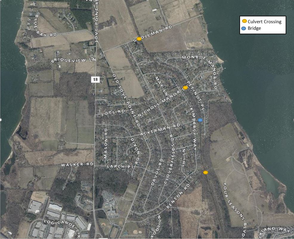
The County maintains public road drainage throughout the Cloverfields subdivision. This maintenance is limited to grass drainage swales along County roads and road culverts. There are four culvert crossings located adjacent to the Cloverfields Community. Flood studies estimated minor improvements to flooding impacts (less then 0.5 foot reduction) for removing these culverts. Removing or cleaning out culverts helps water move faster in most cases, however, as water empties into tidal waters of Cox Creek, tide level will often be the driving factor of the drainage rate. Sea level rise will further exasperate drainage issues.
- Remove two Benton’s Road 60″ culverts (Completed 2012)
- Nicholas Manor Drive Crossing: Will be replaced with a concrete box culvert (estimated 2021)
- Grollman Road 54″ culvert: not scheduled or recommended to be removed
- Divert run-off north or south of the community to the Chester River: Would require over a 13 foot deep drainage ditch
Community Led Drainage Swale and Channel Maintenance (County Assistance)
Without County easements along the channel, responsibility falls upon individual property owners for maintenance of their portions of the drainage ditch which runs through the Community (see history). With Cox Creek flowing southward through Cloverfields, any constrictions to the flow-path will cause the water to move slower and flooding will occur. Each property owner should attempt to remove any fallen trees, trash and yard debris from the ditch. Property owners should not place structures or lawn debris (i.e. lawn clippings, tree branches and leaves) in the ditch.
Should the community desire, they could reform a drainage association to communally manage maintenance. Taking the following actions could reduce the effects of riverine flooding but would not impact tidal flooding events:
- Dredge any sand or silt obstructions from existing drainage channel and remove blockages
- Remove fallen trees from drainage conveyance
- Channel Improvements just downstream of Grollman Road: Excavating overbank areas to provide additional floodplain capacity for approximately 500 linear feet. This reduces the 2-year, 10-year, and 100-year elevation by approximately 0.4 feet.
- Channel Improvements upstream of Ackerman Road: Create a better defined channel and clear the channel upstream of Ackerman Road. Clearing a twenty-foot wide channel would reduce surface elevations 0.3-0.6 feet. Would likely require wetland permitting and would require the loss of a portion of backyards for the properties along the ditch.
- Homeowner education on not dumping leaves or yard debris
Public/ Private Partnerships
- Apply for Federal grants to evaluate the cost benefit of the strategies outlined on this page and implement community based solutions. In addition to the channel stabilization strategies identified above, additional strategies include:
- Purchase of severe repetitive loss properties for additional flood storage
- Stormwater retrofits designed to assist with flood mitigation
- Agricultural easements or purchase of surrounding agricultural property using open space funding to avoid future build out
Public Drainage Association Information
MD Department of Ag- Public Drainage/Watershed Associations
Public Drainage Associations: Laws and Regulations
Resources for flood mitigation for Individual Property Owners
QAC GIS Property Viewer (layers for flood plain)