Cloverfields Flooding
Flooding in Cloverfields is influenced by a large upstream drainage area – 700 acres of predominately agricultural land and the low-lying topography of the land through the community, which also make it vulnerable to tidal influences. Water has historically flowed along the lowest land or riverine floodplain in what now makes up Cloverfields paralleling Kimberly Way. Significant flood events occur when intense or prolonged rain events coincide with high tides. However, it wasn’t until the construction of homes on the lots directly abutting the Creek, beginning in the mid-1990s, that the historical flooding went from mere agricultural nuisance events to events with the potential of property damage.
Although maps prepared by the National Flood Insurance Program failed to identify the extent of flood potential for Cox Creek, much of the pre-developed Cloverfields community was designated as wetlands by the Army Corps of Engineers, a classification which had little bearing on community planning in the 1950’s when the Cloverfields lots of record were created. Quite simply, the development of Cloverfields largely predates development regulation as we know it today.
Four Seasons Flood Studies and Stormwater Management
Situated downstream of Cloverfields is the Four Seasons community, a modern subdivision subject to a broad range of federal, state and local regulations intended for the protection of persons, property and the environment – two such regulations being that of floodplain and stormwater management.
Modern day subdivisions must show they are managing flood risk; both for their own property and existing property of others. Parts of the Four Seasons community are located in different drainage areas than Cloverfields. Landscaped berms in these portions of the community further reinforced flow pattern directions that divided the two drainage areas. Flood studies conducted for Four Seasons within the riverine floodplain shared with Cloverfields led to updated Floodplain Maps adopted by the Federal Emergency Management Agency (FEMA). Any fill (soil brought in to elevate development above floodplain elevations) must be accompanied by studies which show negligible impact to riverine flood elevations. According to the design engineer, the Four Seasons development in the riverine influenced floodplain results in 5.45 net cubic yards of more storage volume (cut versus fill). The full engineering analysis of the Four Seasons development effect on flood elevations can be found here. This accounted for disturbance of some sections of new roads that were not built and also did not account for an additional floodplain mitigation area that provides additional flood storage. Tidal flooding will affect Cloverfields and Four Seasons independent of development effects. Four Seasons is likely more protected due to higher elevation standards and flood control provisions in building construction standards.
Modern day subdivisions must prepare and implement stormwater management plans, consistent with the Maryland Department of Environment (MDE) Stormwater Design Manual, which provide protection against adverse impacts of stormwater runoff. The Cloverfields community was not required to do any such analysis as it was created before the County, or State, had any type of performance standard of this nature that a subdivision had to meet. The Four Seasons design engineer submitted stormwater reports that demonstrated decreased runoff from the 2, 10, and 100-year flood events post-development (See table 1) for the drainage areas that abut Cloverfields and share common outfalls to Cox Creek. Improvements can be attributed to stormwater management controls including stormwater detention ponds, bioretention, and rainwater harvest facilities located throughout the community. With stormwater facilities in place, it is possible for the completed Four Seasons residential community to result in less stormwater runoff and pollution than that which would be generated by the pre-developed farm fields.
The Cloverfields data developed under floodplain studies mentioned above were utilized in planning for the stormwater times of concentration, or the time it takes water to reach an outfall location over the drainage area. Four Seasons was designed specifically to reach common outfall points as Cloverfields at different times so as to spread the movement of water across the riverine floodplain out over time and lower the peak discharge entering Cox Creek.
Table 1. Lane Engineering Four Seasons Design Calculations for Runoff rates
| Storm Event | Pre-Development/ Row Crop Peak Runoff Rate (cfs) | Post Development Peak Runoff Rate (cfs) | Reduction (cfs) |
| 2 year | 23.28 | 5.50 | 17.78 |
| 10 year | 45.61 | 18.91 | 26.70 |
| 100 year | 70.54 | 26.39 | 44.15 |
Environmental Impact Mitigation for Cloverfields and Four Seasons Development
Whereas previously much of Cox Creek had been tilled to the shoreline, it is today enveloped largely by a three hundred-foot (300’) wide forested buffer. This equates to 25 acres of increased tree buffer from pre Four Seasons development conditions. This accomplishment can largely be attributed to the Four Seasons development. The development itself necessitated the creation of over one mile of new buffer along the east shore of Cox Creek. Additionally, the Four Seasons developer donated to the County 138 acres of land west of Cox Creek – land which abuts existing County-owned property to the north and west, thereby enabling the establishment of a continuous, two-mile long, vegetated shore buffer extending from Cloverfields down to Maryland Route 18. This site is also the location of a future wetland mitigation site for the wetlands disturbed by the Cloverfields development.
Benefits of a Buffer
Forested buffers help absorb the effects of both non-point pollution or farmland runoff entering Cox Creek and post development point pollution from impervious areas within developments such as Cloverfields and Four Seasons. Shore buffers provide multiple benefits which include:
- Filter sediment, excess nutrients, and potentially harmful substances from stormwater runoff
- Preventing or reducing erosion through slowing runoff and stabilizing the shoreline
- Maintaining an area of habitat along shorelines and streams
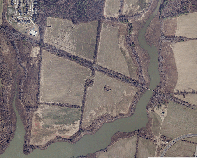
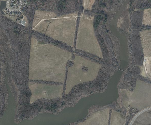
Cox Creek shore buffers pre (above) and post (below) Four Seasons development
Cloverfields Flood Mitigation
The Federal Emergency Management Agency (FEMA) cautions against using the terms “in a floodplain” and “out of a floodplain”. Most of Kent Island has some degree of flood risk. The mapped and regulated requirements of the “100-year flood” should not be confused with the notion that areas in this mapped area will only flood once in a hundred years. Statistically, there is a one-in-four (25%) chance that flooding will occur at least once to a home located in the mapped 100-year floodplain during the life of a 30-year mortgage. Modern day building standards minimize flood damage in high risk areas. Unfortunately, many homes in Cloverfields were constructed prior to the enactment of these standards. There are however, many remedies for older structures. Queen Anne’s County participates in the National Flood Insurance Program (NFIP), which is a federal program designed to guide community-enforced building and zoning ordinances, establish floodplain mapping, and provide access to affordable, federally-backed flood insurance protection for property owners. Additional information may be found here.
In addition to the community-based drainage maintenance solutions mentioned elsewhere on this site, the only way to significantly lessen the degree of flooding in Cloverfields is to reduce the drainage area coming to the community. As all the contributing drainage areas are upstream, or north and west, of Cloverfields, it could be of value to study the impact that detention ponds would have on the north and west sides of Cloverfields to slow and detain stormwater before it gets to Cloverfields. However, these upland drainage areas exist as private property, so cooperation from these landowners would be essential to any successful mitigation. This combined with maintenance of drainage conveyances through Cloverfields (for uninhibited drainage through the community itself) may provide minor reductions in flood elevations.